MRA running on DMD
-
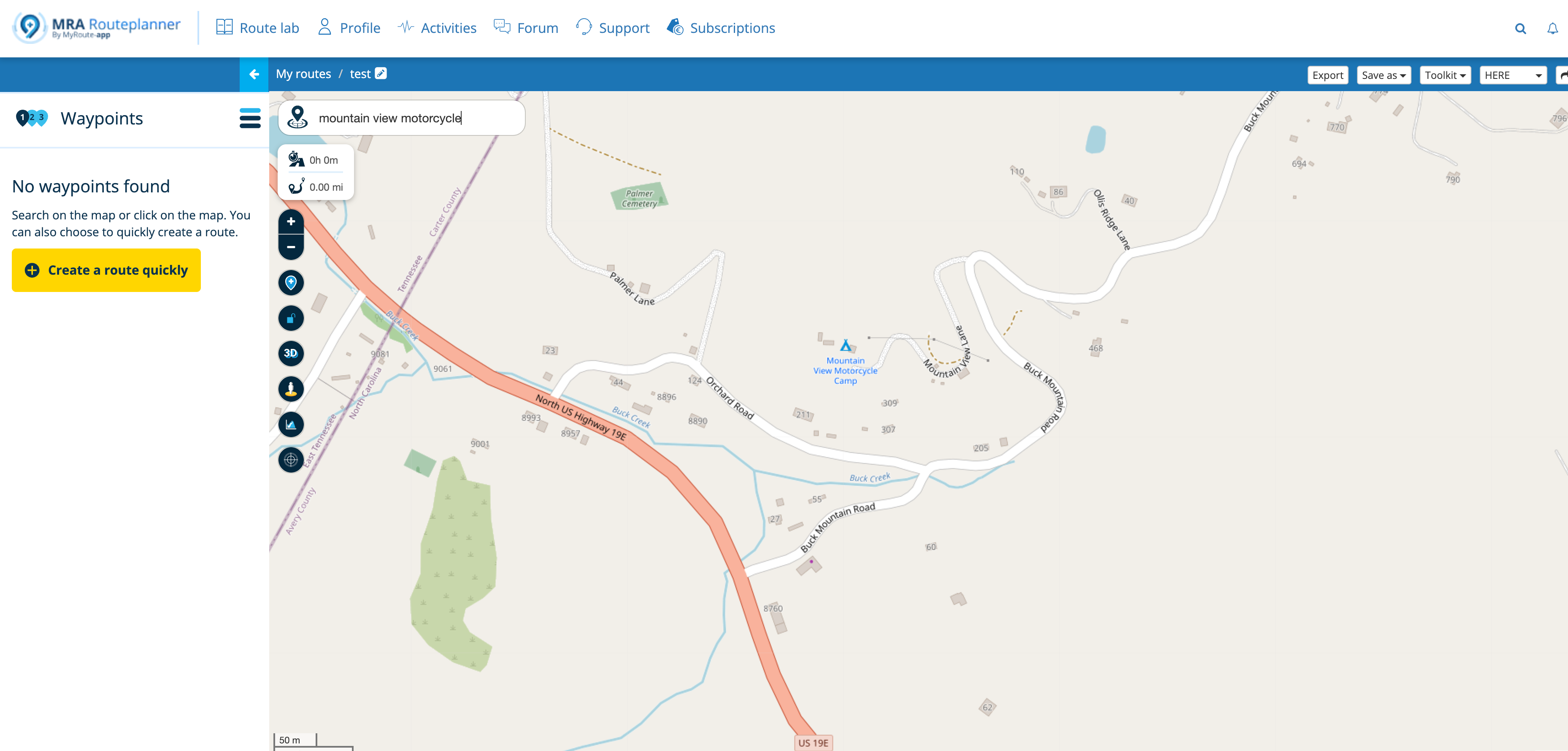
For me it would be interesting to use MRA with DMD Hardware using the BMW Wonderwheel. This would be my favourite equipment for on road navigation, especially of zooming and skipping waypoints is possible…. may be someone has some experiences with this showcase?
-
Excellent summary!
I agree with you 100%, both in terms of the facts and your assessments.
I want to add something about POIs, as they can also easily be confused with DMD2.
In the MRA POI area, we see three tabs, and it is essential to understand that these POIs have different contexts.
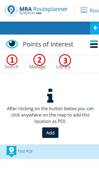
#1 and #3 are like libraries; #1 "search" contains the POIs from the map, and #3 "library" is a private library. These POIs are not directly related to the route but are, so to speak, above it. These libraries also exist in DMD2, one via "search" for the map POIs, and the other via "myLocations" for the private library.
#2 "manage," on the other hand, contains the POIs that are actually assigned to the route, and only these are included in the GPX file as <wpt> when exported.
So if you want to transfer MRA POIs to DMD2 (where they are called waypoints), you have to insert them in tab #3.
@Martin-Wilcke ... hi Martin, I'm so sorry about, but that's not 1000% correct

It's so important to talk with correct wording...
If you open a route in MRA (no matter if a new, or existing one), than you can add POI.- by selecting a category from in MRA existing POI list in tab "search"
- or by activating/selecting a imported POI list in tab "Library"
then (if you zoom in the map) you will see many POI about the selected category(s)
then you can click on one or several of those just visible POIs in map, to make them "embedded" in the map -> will be included in an exported gpx file as <wpt>. case#1
and/or you can make them really as route point -> will be included in an exported gpx file as <rtept>. case#2
if you check both checkboxes in the dialog, you will get a route point and a POI. Icons are laying then on each other in map, may you can't see both. - or by creating a POI on the fly by using tab "Manage", clicking button "Add", paning the map and entering so manually a location as POI in the map case#1
- If you close this route and reopen again, the entered POIs case#1 are still visible - on map and on POI list "Manage" in MRA.
But the POIs are - let me say "only aggregated to this route(file)"! Still not part of the calculated route as routepoint! - If you navigate this route by MyRoute-App, entered POI of case#1 will be visible on map too, but you will not be guided to it!
- If you exported the route as gpx file, and imported the file in DMD2, entered POI of case#1 will be visible on map (and GPX-Manager) too, but you will not be guided to it!
- If you navigate this route by MyRoute-App, entered POI of case#2 will be visible on map too, and you will be guided to it!
- If you exported the route as gpx file, and imported the file in DMD2, entered POI of case#2 will be visible on map too, but not in GPX-Manager, and you will not be guided to it!
puhh - I hope, I have described each case, would have nothing overseen, and you can understand my explanations

Nothing is impossible ;-)
In past: GARMIN Zumo 210->GARMIN Zumo 395->GARMIN XT=> now: DMD T865-X + MyRoute-App, LocusMaps, OsmAnd.
In past: GARMIN MapSource ->GARMIN BaseCamp->Tyre->Kurviger->Calimoto=> now: MRA-Routplanner. -
@Martin-Wilcke ... hi Martin, I'm so sorry about, but that's not 1000% correct
It's so important to talk with correct wording...
If you open a route in MRA (no matter if a new, or existing one), than you can add POI.- by selecting a category from in MRA existing POI list in tab "search"
- or by activating/selecting a imported POI list in tab "Library"
then (if you zoom in the map) you will see many POI about the selected category(s)
then you can click on one or several of those just visible POIs in map, to make them "embedded" in the map -> will be included in an exported gpx file as <wpt>. case#1
and/or you can make them really as route point -> will be included in an exported gpx file as <rtept>. case#2
if you check both checkboxes in the dialog, you will get a route point and a POI. Icons are laying then on each other in map, may you can't see both. - or by creating a POI on the fly by using tab "Manage", clicking button "Add", paning the map and entering so manually a location as POI in the map case#1
- If you close this route and reopen again, the entered POIs case#1 are still visible - on map and on POI list "Manage" in MRA.
But the POIs are - let me say "only aggregated to this route(file)"! Still not part of the calculated route as routepoint! - If you navigate this route by MyRoute-App, entered POI of case#1 will be visible on map too, but you will not be guided to it!
- If you exported the route as gpx file, and imported the file in DMD2, entered POI of case#1 will be visible on map (and GPX-Manager) too, but you will not be guided to it!
- If you navigate this route by MyRoute-App, entered POI of case#2 will be visible on map too, and you will be guided to it!
- If you exported the route as gpx file, and imported the file in DMD2, entered POI of case#2 will be visible on map too, but not in GPX-Manager, and you will not be guided to it!
puhh - I hope, I have described each case, would have nothing overseen, and you can understand my explanations
Lots of thoughts - let's sort them out
")
Firstly, this topic is about "MRA running on DMD", so everything related to "open in MRA" or "run/navigate with MRA" is probably right, I haven't checked, but out of scope here. No offence intended!
My addition to your summary is about "how to create points/items in MRA that show up in DMD as a waypoint (GPX terminology)". There are several ways to do so, right, but either way, we have to make sure they appear in tab #2 ("manage"). All these items, and only these items, are exported as <wpt> and therefore become waypoints in DMD. Do you agree on this?
Rereading my posting, there's a typo in the last sentence:
So if you want to transfer MRA POIs to DMD2 (where they are called waypoints), you have to insert them in tab #3.
That's wrong, I meant: "...you have to insert them in tab #2".
Finally, and this is a common misunderstanding as well, DMD will not "guide" you to waypoints (GPX terminology). You have a line on the map you can follow, and you may get turn-by-turn instructions; however, they will guide you through the route or track, but not to waypoints at all!
Waypoints, on the other hand, are announced, and you'll get the remaining distance to the next one along the route/track, even if they are not precisely located "on the line". But you will not be guided to them; there's no "turn right now", they're just along.To compare this with MRA: You see the line, you get TBTs that guide you from one waypoint (MRA terminology) to another, you get the distance to the next waypoint, and they are announced. POIs, on the other hand, will show up on the map, but there's no guidance to them.
And here's what drives most users crazy: waypoints are announced in both MRA and DMD, and you get the distance to them. It sounds the same, but it refers to entirely different objects! @Con-Hennekens : yes, it's semantics

-
Lots of thoughts - let's sort them out
Firstly, this topic is about "MRA running on DMD", so everything related to "open in MRA" or "run/navigate with MRA" is probably right, I haven't checked, but out of scope here. No offence intended!
My addition to your summary is about "how to create points/items in MRA that show up in DMD as a waypoint (GPX terminology)". There are several ways to do so, right, but either way, we have to make sure they appear in tab #2 ("manage"). All these items, and only these items, are exported as <wpt> and therefore become waypoints in DMD. Do you agree on this?
Rereading my posting, there's a typo in the last sentence:
So if you want to transfer MRA POIs to DMD2 (where they are called waypoints), you have to insert them in tab #3.
That's wrong, I meant: "...you have to insert them in tab #2".
Finally, and this is a common misunderstanding as well, DMD will not "guide" you to waypoints (GPX terminology). You have a line on the map you can follow, and you may get turn-by-turn instructions; however, they will guide you through the route or track, but not to waypoints at all!
Waypoints, on the other hand, are announced, and you'll get the remaining distance to the next one along the route/track, even if they are not precisely located "on the line". But you will not be guided to them; there's no "turn right now", they're just along.To compare this with MRA: You see the line, you get TBTs that guide you from one waypoint (MRA terminology) to another, you get the distance to the next waypoint, and they are announced. POIs, on the other hand, will show up on the map, but there's no guidance to them.
And here's what drives most users crazy: waypoints are announced in both MRA and DMD, and you get the distance to them. It sounds the same, but it refers to entirely different objects! @Con-Hennekens : yes, it's semantics
@Martin-Wilcke fine with you Martin

-
Lots of thoughts - let's sort them out
Firstly, this topic is about "MRA running on DMD", so everything related to "open in MRA" or "run/navigate with MRA" is probably right, I haven't checked, but out of scope here. No offence intended!
My addition to your summary is about "how to create points/items in MRA that show up in DMD as a waypoint (GPX terminology)". There are several ways to do so, right, but either way, we have to make sure they appear in tab #2 ("manage"). All these items, and only these items, are exported as <wpt> and therefore become waypoints in DMD. Do you agree on this?
Rereading my posting, there's a typo in the last sentence:
So if you want to transfer MRA POIs to DMD2 (where they are called waypoints), you have to insert them in tab #3.
That's wrong, I meant: "...you have to insert them in tab #2".
Finally, and this is a common misunderstanding as well, DMD will not "guide" you to waypoints (GPX terminology). You have a line on the map you can follow, and you may get turn-by-turn instructions; however, they will guide you through the route or track, but not to waypoints at all!
Waypoints, on the other hand, are announced, and you'll get the remaining distance to the next one along the route/track, even if they are not precisely located "on the line". But you will not be guided to them; there's no "turn right now", they're just along.To compare this with MRA: You see the line, you get TBTs that guide you from one waypoint (MRA terminology) to another, you get the distance to the next waypoint, and they are announced. POIs, on the other hand, will show up on the map, but there's no guidance to them.
And here's what drives most users crazy: waypoints are announced in both MRA and DMD, and you get the distance to them. It sounds the same, but it refers to entirely different objects! @Con-Hennekens : yes, it's semantics
@Martin-Wilcke, I think the confusion is caused mainly by those who use multiple interpretations in one comment...
If we just call a POI a POI instead of a waypoint, all confusion is gone. I don't know if I understood completely what you said, but POI are never announced in MRA (just to be clear), I do not know if they are announced in DMD.I am just an enthusiastic MRA user, and hope you will be one too!
Most motorcycle problems are caused by the nut that connects the handlebar to the saddle.
Check out RideSleepRepeat.eu, a biker community for sharing stays across Europe
-
@Martin-Wilcke, I think the confusion is caused mainly by those who use multiple interpretations in one comment...
If we just call a POI a POI instead of a waypoint, all confusion is gone. I don't know if I understood completely what you said, but POI are never announced in MRA (just to be clear), I do not know if they are announced in DMD.@Con-Hennekens said in MRA running on DMD:
@Martin-Wilcke, POI are never announced in MRA (just to be clear), I do not know if they are announced in DMD.
Yep, they are. We’re talking about different concepts here.
And regarding naming: I’d suggest route-waypoint vs POI-waypoint. -
@Con-Hennekens said in MRA running on DMD:
@Martin-Wilcke, POI are never announced in MRA (just to be clear), I do not know if they are announced in DMD.
Yep, they are. We’re talking about different concepts here.
And regarding naming: I’d suggest route-waypoint vs POI-waypoint.@Martin-Wilcke said in MRA running on DMD:
And regarding naming: I’d suggest route-waypoint vs POI-waypoint.
I will NOT go into this, since I have promised no flamewar earlier...
I am just an enthusiastic MRA user, and hope you will be one too!
Most motorcycle problems are caused by the nut that connects the handlebar to the saddle.
Check out RideSleepRepeat.eu, a biker community for sharing stays across Europe
-
@Martin-Wilcke said in MRA running on DMD:
And regarding naming: I’d suggest route-waypoint vs POI-waypoint.
I will NOT go into this, since I have promised no flamewar earlier...
It's not about flaming. It's about sharing ideas, thoughts, and opinions about MRA compared to other concepts.
Some users are happy with the navigation ecosystem they are used to, and they are not interested in any other. That's absolutely fine.
But others are. And an increasing number of them are shifting to a workflow where they plan with MRA and navigate with DMD (or at least they are curious about how it works). Most of them are struggling with the different meanings of "waypoint" and "POI" - and there are differences, as @Guzzist and I pointed out.
Simply put, it does not make sense to consistently refer to POIs as POIs and waypoints as waypoints when they have entirely different meanings in different contexts. Why is it so difficult to understand?
-
It's not about flaming. It's about sharing ideas, thoughts, and opinions about MRA compared to other concepts.
Some users are happy with the navigation ecosystem they are used to, and they are not interested in any other. That's absolutely fine.
But others are. And an increasing number of them are shifting to a workflow where they plan with MRA and navigate with DMD (or at least they are curious about how it works). Most of them are struggling with the different meanings of "waypoint" and "POI" - and there are differences, as @Guzzist and I pointed out.
Simply put, it does not make sense to consistently refer to POIs as POIs and waypoints as waypoints when they have entirely different meanings in different contexts. Why is it so difficult to understand?
@Martin-Wilcke, I have quite a clear understanding of what Waypoints and the different kind of waypoints are, and that is not difficult to understand at all
Hello! It looks like you're interested in this conversation, but you don't have an account yet.
Getting fed up of having to scroll through the same posts each visit? When you register for an account, you'll always come back to exactly where you were before, and choose to be notified of new replies (either via email, or push notification). You'll also be able to save bookmarks and upvote posts to show your appreciation to other community members.
With your input, this post could be even better 💗
Register Login-
0672
-
08173
-
08187
-
07159
-
1575
-
0341.6k
-
09400
-
7221.4k