Here Maps not Recognizing Road is now Open
-
@Brian-McG said in Here Maps not Recognizing Road is now Open:
I am very confident that the idea in my first post, using OpenStreetMap or TomTom in offline mode works
I think the above is where some of the confusion is. I don't use offline mode for route planning. I do almost all my route creation in the online Web Routeplanner. I then save routes as GPX 1.1 files for import into my Zumo XT for actual navigation. So, I still maintain it's not possible to use TomTom or OSM (while online) to route on a closed road. If I'm incorrect, I'm all ears for learning something more.
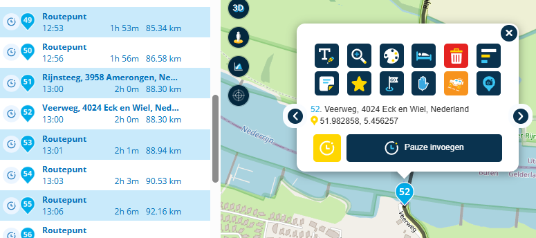
I think the skip function mostly works. It's not perfect, but workable.
@John-S-Parry "Offline" mode refers to navigating with the MRA mobile app so it does not apply to your use case
In my previous post you can see that using TomTom & OpenStreetMap as the routing options they clearly route along the road between Cedar Springs & Big Pines
If I export those routes as GPX1.1 they will be GPX files containing those routes & tracks following that pathWhen you import them into the Zumo & depending on your settings it may re-calculate the route so it detours away from the CA-2 but if you selcect the track it should follow the path from Cedar Springs to Big Pines
-
I tested @Brian-McG's suggestion of exporting the track using the OSM map and he's correct, as can be seen here:
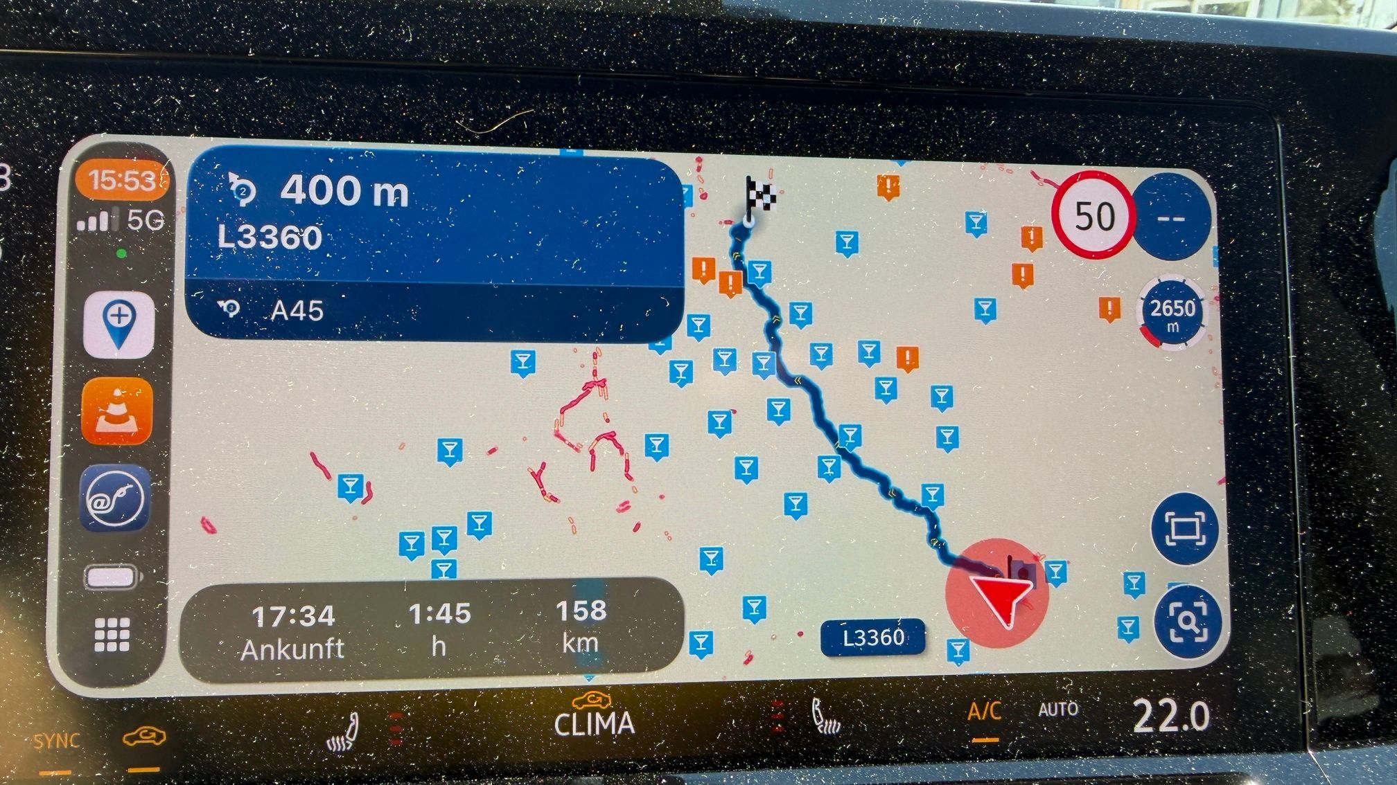
https://www.gpsvisualizer.com/display/map/20250902125300-05119-map.htmlThe red line is the track, the blue line is the route (or rather routing points) that have been exported. Using the Track, the XT should calculate the correct route on its own.
This however does NOT work if you set one of the shaping points to off-road.
When exporting, it appears that in the background the route is calculated, ignoring the 'Skip' setting of the waypoint. If I set the 4th shaping point to skip, it draws a straight line in the routing, but when I export it using the OSM-maps, I still get a nicely routed track (which in some cases is not what you cant) -
@Brian-McG Garmin GPS devices always recalculate when imported. Always. There is no way to turn that off. I intentionally turn off all GPS avoidance settings so that the Garmin calculation algorithms won't be influenced beyond my waypoints.
I don't know what we're doing different. If I create a new named route to start and immediately go into the OSM and/or TomTom layer, I can't create a route anywhere along the closure. The web MRA Routeplanner simply won't don't it.
I normally don't deal with tracks in my routing. I create routes with an abundance of waypoints to ensure directional behavior. In the case of using the MRA skip function, the track created along the closed section gets recalculated into the rest of the route.
How you're getting OSM to route the closed section is still a mystery to me.
-
@Brian-McG Garmin GPS devices always recalculate when imported. Always. There is no way to turn that off. I intentionally turn off all GPS avoidance settings so that the Garmin calculation algorithms won't be influenced beyond my waypoints.
I don't know what we're doing different. If I create a new named route to start and immediately go into the OSM and/or TomTom layer, I can't create a route anywhere along the closure. The web MRA Routeplanner simply won't don't it.
I normally don't deal with tracks in my routing. I create routes with an abundance of waypoints to ensure directional behavior. In the case of using the MRA skip function, the track created along the closed section gets recalculated into the rest of the route.
How you're getting OSM to route the closed section is still a mystery to me.
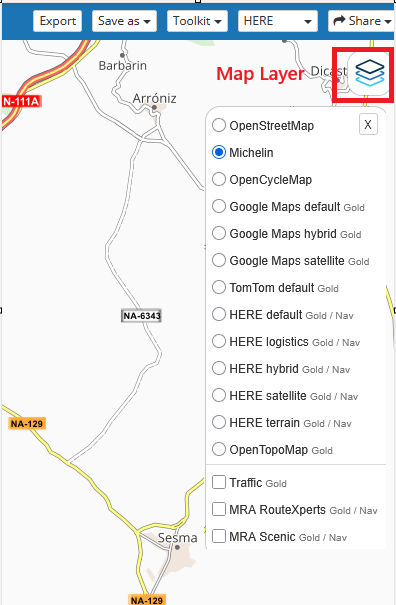
@John-S-Parry the routing calculations in MRA are controlled in this drop down
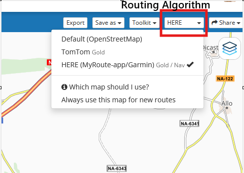
The map layers are just graphic overlays they just show you where the roads are, they are not responsible for calculating the routing, it is irrelavant what Map Layer you use, they just make the screen look nice
-
@Brian-McG We have a block between each other that I don't know how to reconcile. The "skip" function works for my purposes. I'm OK at this point.
-
@Adrian-Avram you can also edit & correct the Here map at https://mapcreator.here.com
unlike OpenStreetMap where the edit is accepted almost immedialltey on trust, with Here each edit is reviewed before acceptance
I find simple edits & changes with Here can take a few days to a couple of weeks OR they are not accepted
if nothing has changed a year after your report then it has probably not been accepted@Brian-McG said in Here Maps not Recognizing Road is now Open:
with Here each edit is reviewed before acceptance
As I said .... With HERE, I reported an issue more than one year ago, and nothing changed ...
Nowadays you can check on Google Maps that a new street was built, if I add it to HERE, but nobody cares even to check and one years passes ?
So I will stick to supporting and editing on OpenStreetMap !Best regards,
AdrianSamsung S24 Ultra and Motorola Thinkphone with Android Auto
MyRoute-APP (Planner+Navigation, GOLD Lifetime)
Honda NC750X (2021) with CHIGEE Aio-5 Play -
@Brian-McG said in Here Maps not Recognizing Road is now Open:
with Here each edit is reviewed before acceptance
As I said .... With HERE, I reported an issue more than one year ago, and nothing changed ...
Nowadays you can check on Google Maps that a new street was built, if I add it to HERE, but nobody cares even to check and one years passes ?
So I will stick to supporting and editing on OpenStreetMap !@Adrian-Avram said in Here Maps not Recognizing Road is now Open:
So I will stick to supporting and editing on OpenStreetMap !
Totally fine, but not helpful for MRA Navigation.
I have heard much quicker acceptance of feedback from HERE too, by the way.I am just an enthusiastic MRA user, and hope you will be one too!
Most motorcycle problems are caused by the nut that connects the handlebar to the saddle.
Check out RideSleepRepeat.eu, a biker community for sharing stays across Europe
-
@Adrian-Avram said in Here Maps not Recognizing Road is now Open:
So I will stick to supporting and editing on OpenStreetMap !
Totally fine, but not helpful for MRA Navigation.
I have heard much quicker acceptance of feedback from HERE too, by the way.@Con-Hennekens well what can I say ... I tried, but its useless unless they will leave people to change the map and improve it. Here map is much limited than OSM map unfortunately ...
Best regards,
AdrianSamsung S24 Ultra and Motorola Thinkphone with Android Auto
MyRoute-APP (Planner+Navigation, GOLD Lifetime)
Honda NC750X (2021) with CHIGEE Aio-5 Play -
@Con-Hennekens well what can I say ... I tried, but its useless unless they will leave people to change the map and improve it. Here map is much limited than OSM map unfortunately ...
@Adrian-Avram, I understand what you are saying, but MRA Navigation happens to use HERE maps, not OSM.
I am just an enthusiastic MRA user, and hope you will be one too!
Most motorcycle problems are caused by the nut that connects the handlebar to the saddle.
Check out RideSleepRepeat.eu, a biker community for sharing stays across Europe
-
@Adrian-Avram, I understand what you are saying, but MRA Navigation happens to use HERE maps, not OSM.
@Con-Hennekens yes I know ... unfortunately


-
@Brian-McG I now understand what you did. I missed where you actually changed the calculation map from HERE to OSM. I had in my head that you were simply changing to the OSM overlay on a HERE calculation map.
So yes, that method works.
 Thanks.
Hello! It looks like you're interested in this conversation, but you don't have an account yet.
Getting fed up of having to scroll through the same posts each visit? When you register for an account, you'll always come back to exactly where you were before, and choose to be notified of new replies (either via email, or push notification). You'll also be able to save bookmarks and upvote posts to show your appreciation to other community members.
With your input, this post could be even better 💗
Register Login-
0541
-
09138
-
012253
-
05108
-
0486
-
1413225
-
0386
-
0331