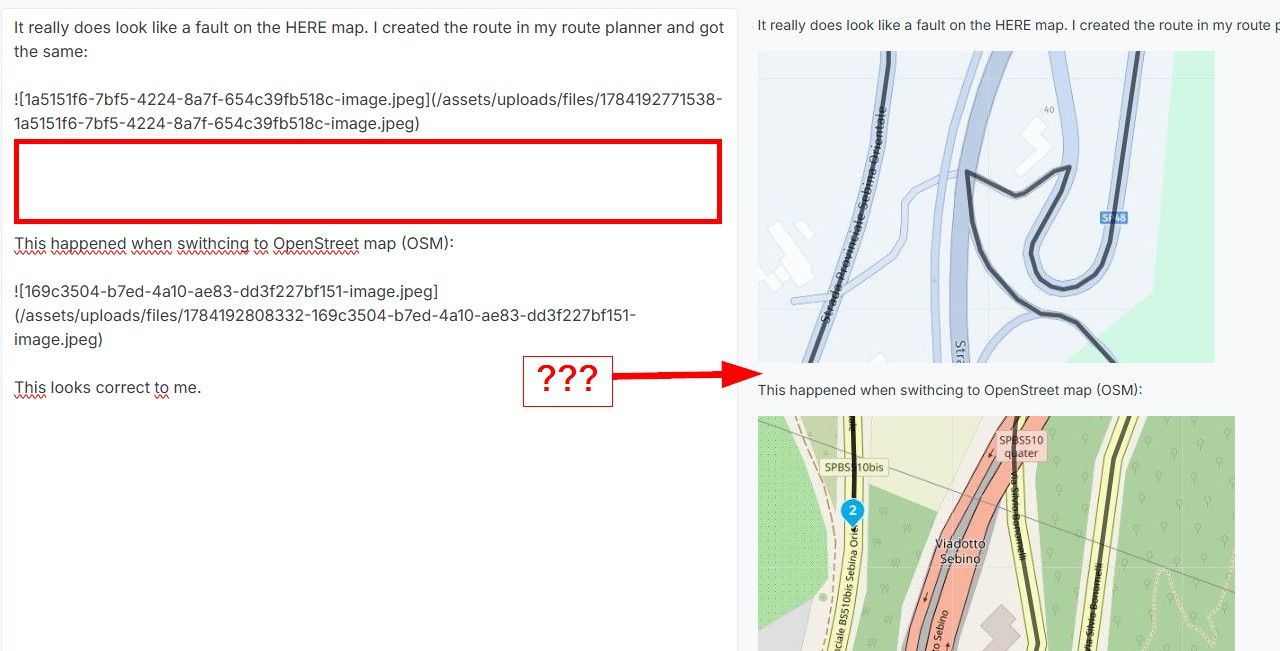
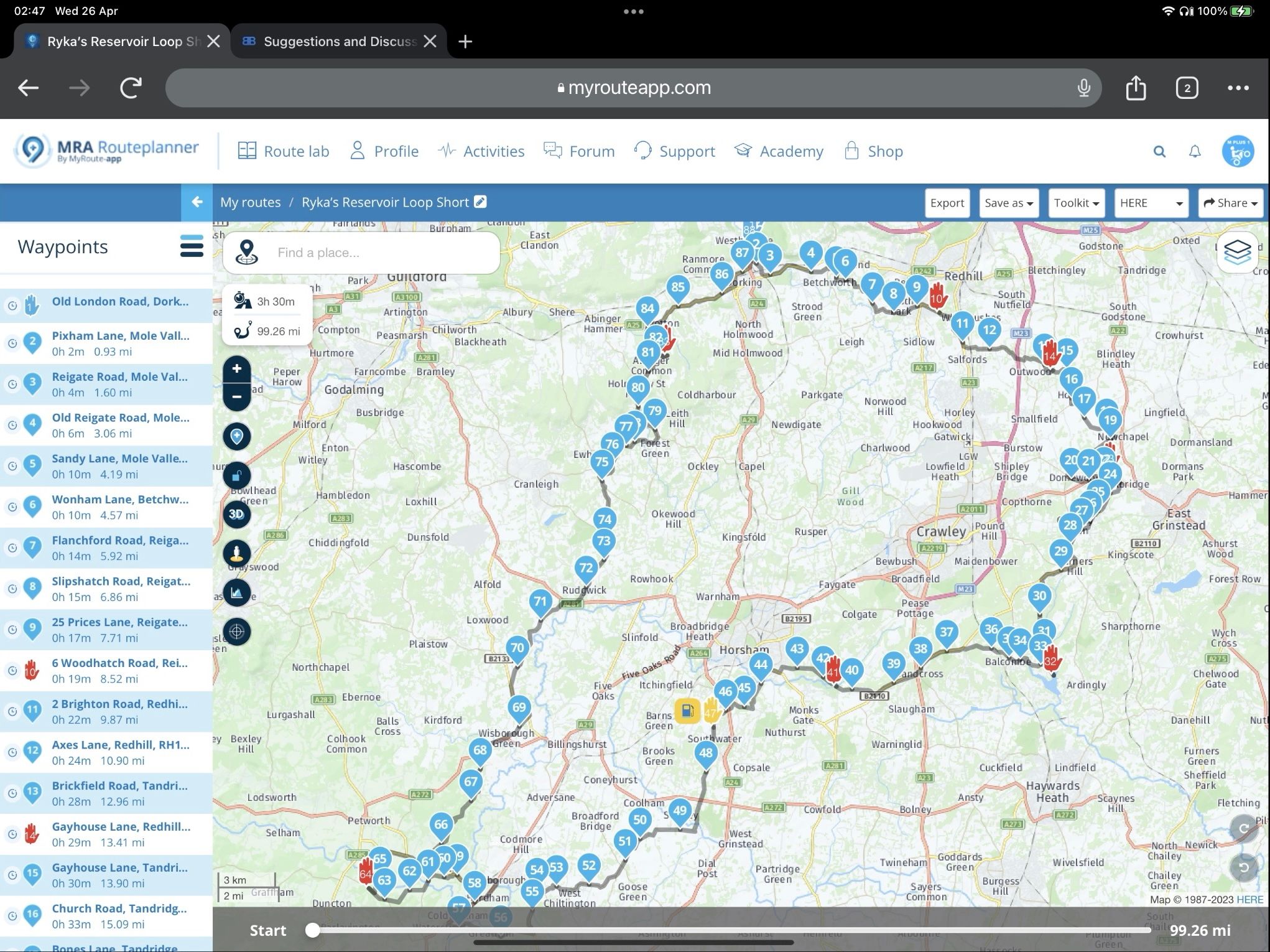
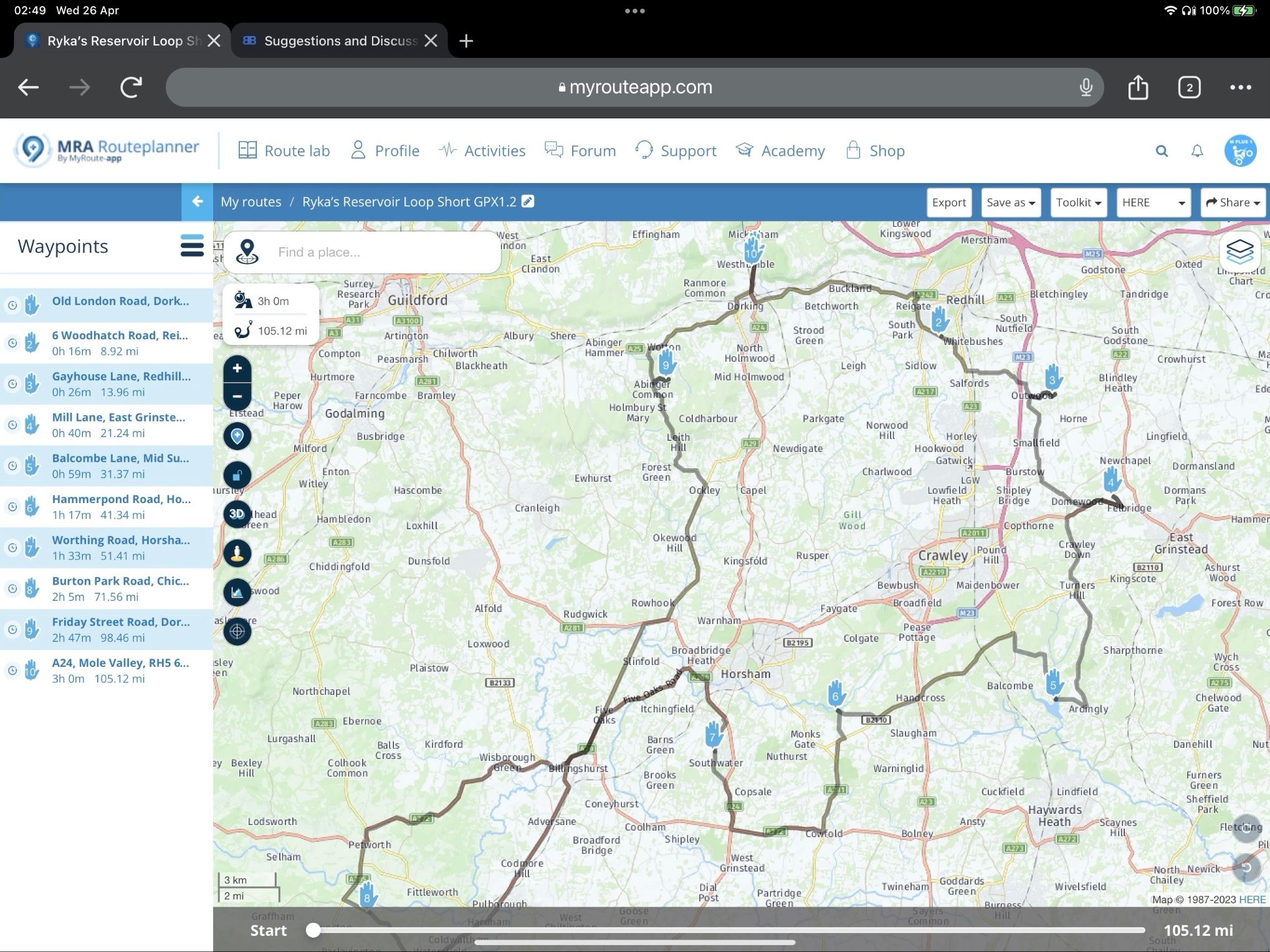
Simulating a GPX1.2 Route in MRA Navigation Next
-
@Lynchy67, Then you would need to import it as a track and not as a route, but that will most likely also skip the Via points...
I would prefer an option in the toolkit to copy a route to a route-track. It would be great if shaping points became absent, but even greater if colored shaping points, shaping points with a remark and all via-points would stil be present. Maybe in the form POI's, because they carry a relevance to the route-track that people will want to see on screen during their ride.
Therein lies the problem as the creation of the Track was always managed directly on the Garmin XT when using GPX1.2
Personally, I have no problem seeing Shaping Points in a route but others seem to want them hidden.
If I'm on the bike on my own I always use a Route-Track and I stop just for Scenery, Food/Drink/Petrol or just to stretch my legs, but if "She who must be obeyed" is out with me then I have to have a specific plan for stops and will therefore plan appropriately.
-
@Lynchy67 said in Simulating a GPX1.2 Route in MRA Navigation Next:
Therein lies the problem as the creation of the Track was always managed directly on the Garmin XT when using GPX1.2
I don't think that is correct. As far as I know the track is generated during the GPX export by MRA. The GPX contains a route as well as a track (except GPX1.2 I believe but that is beyond my Zumo experience. I haven't touched it since the introduction of MRA Navigation
") ). On the garmin you can choose to convert the track to a trip (their take on a route) and that trip follows the track exactly.
). On the garmin you can choose to convert the track to a trip (their take on a route) and that trip follows the track exactly.I am just an enthusiastic MRA user, and hope you will be one too!
Most motorcycle problems are caused by the nut that connects the handlebar to the saddle.
Check out RideSleepRepeat.eu, a biker community for sharing stays across Europe
-
@Lynchy67 said in Simulating a GPX1.2 Route in MRA Navigation Next:
Therein lies the problem as the creation of the Track was always managed directly on the Garmin XT when using GPX1.2
I don't think that is correct. As far as I know the track is generated during the GPX export by MRA. The GPX contains a route as well as a track (except GPX1.2 I believe but that is beyond my Zumo experience. I haven't touched it since the introduction of MRA Navigation
). On the garmin you can choose to convert the track to a trip (their take on a route) and that trip follows the track exactly.I’m the same, haven’t used the XT for ages but I do always take it with me.
-
@Con-Hennekens De export van een GPX 1.2 versie bevat zowel de track als de route. Deze importeer ik in mijn BMW Navigator V en ik kan de track zichtbaar maken als een lijn, én de route gebruiken. De vormpunten zijn niet in de kaart (overzicht) of in de route te zien, de VIA punten gelukkig wel. Jarenlang heb ik Basecamp gebruikt om de track zichtbaar op mijn Navigator V te hebben én de route (en overigens ook de POI's).
Samengevat, MyRoute App (website) exporteert via GPX 1.2 zowel de POI's, de track en de route. Op een Garmin of Navigator V of VI kun je de track zichtbaar maken (via "Sporen") en in beeld houden op de kaart.
Suggestie: Een zichtbare track zou in MRA Navigation Next heel erg welkom zijn!
-
With route navigation we are able to hide shapingpoints from the map but they will always be used for the internal route calculation. So even if we hide them from the map - the upcoming waypoint will always show the shapingpoints too. If we also only show viapoints in the upcoming waypoint then skipping points will have very weird side effects.
Example: you have a route with start - 20x shaping - 1x via (call this A) - 10x shaping - 1x via (call this B) - ….
If we would only show via points and you skip one while you are at the start of the route you would therefore skip A meaning that the app will start routing you to B. That means that the fastest route will be calculated from your position to B. Skipping a total of 30 shaping points. Easy conclusion: upcoming waypoint must show them all.
If you want to skip to the next via point? Just use the waypoint list.
Hiding shapingpoints from the map? That’s possible but will more likely lead to more confusion rather than less. You won’t see the points that are actively used for route calculation.Now track navigation. We could show via points on the map but they won’t be included in the route calculation and you can’t have any interaction with them. Again: probably more confusing.
Not an easy discussion
") Especially for now we shouldn’t make it too confusing for the mass.
Especially for now we shouldn’t make it too confusing for the mass. -
With route navigation we are able to hide shapingpoints from the map but they will always be used for the internal route calculation. So even if we hide them from the map - the upcoming waypoint will always show the shapingpoints too. If we also only show viapoints in the upcoming waypoint then skipping points will have very weird side effects.
Example: you have a route with start - 20x shaping - 1x via (call this A) - 10x shaping - 1x via (call this B) - ….
If we would only show via points and you skip one while you are at the start of the route you would therefore skip A meaning that the app will start routing you to B. That means that the fastest route will be calculated from your position to B. Skipping a total of 30 shaping points. Easy conclusion: upcoming waypoint must show them all.
If you want to skip to the next via point? Just use the waypoint list.
Hiding shapingpoints from the map? That’s possible but will more likely lead to more confusion rather than less. You won’t see the points that are actively used for route calculation.Now track navigation. We could show via points on the map but they won’t be included in the route calculation and you can’t have any interaction with them. Again: probably more confusing.
Not an easy discussion
Especially for now we shouldn’t make it too confusing for the mass.You bring up things behind the scenes that I never considered.
I get it now though, so I am happy to retract my request for GPX1.2 style routes.
I actually don't mind seeing Waypoints, as someone who literally puts at least one Shaping Point on every road I travel on just to ensure that the HERE map doesn't make decisions for me.
I only use routes if "she who must be obeyed" is out on the bike with me.
If I am out on my own its always a Route-Track.For me the app is perfect the way I use it, and I say that knowing there is still more to come.
We have a bank holiday weekend in the UK this week, the Tiger will definitely getting its legs stretched.
Enjoy the weekend.You don’t stop riding when you get old, you get old when you stop riding.
-
You bring up things behind the scenes that I never considered.
I get it now though, so I am happy to retract my request for GPX1.2 style routes.
I actually don't mind seeing Waypoints, as someone who literally puts at least one Shaping Point on every road I travel on just to ensure that the HERE map doesn't make decisions for me.
I only use routes if "she who must be obeyed" is out on the bike with me.
If I am out on my own its always a Route-Track.For me the app is perfect the way I use it, and I say that knowing there is still more to come.
We have a bank holiday weekend in the UK this week, the Tiger will definitely getting its legs stretched.
Enjoy the weekend.@Lynchy67 happy stretching!
Yeah some requests may seem possible (or even easy) but technically they can be far more difficult. -
With route navigation we are able to hide shapingpoints from the map but they will always be used for the internal route calculation. So even if we hide them from the map - the upcoming waypoint will always show the shapingpoints too. If we also only show viapoints in the upcoming waypoint then skipping points will have very weird side effects.
Example: you have a route with start - 20x shaping - 1x via (call this A) - 10x shaping - 1x via (call this B) - ….
If we would only show via points and you skip one while you are at the start of the route you would therefore skip A meaning that the app will start routing you to B. That means that the fastest route will be calculated from your position to B. Skipping a total of 30 shaping points. Easy conclusion: upcoming waypoint must show them all.
If you want to skip to the next via point? Just use the waypoint list.
Hiding shapingpoints from the map? That’s possible but will more likely lead to more confusion rather than less. You won’t see the points that are actively used for route calculation.Now track navigation. We could show via points on the map but they won’t be included in the route calculation and you can’t have any interaction with them. Again: probably more confusing.
Not an easy discussion
Especially for now we shouldn’t make it too confusing for the mass.@Corjan-Meijerink said in Simulating a GPX1.2 Route in MRA Navigation Next:
Example: you have a route with start - 20x shaping - 1x via (call this A) - 10x shaping - 1x via (call this B) - ….
If we would only show via points and you skip one while you are at the start of the route you would therefore skip A meaning that the app will start routing you to B. That means that the fastest route will be calculated from your position to B. Skipping a total of 30 shaping points.This is purely a question for my own understanding, but in this scenario why would the app not try and route from the current position to the first shaping point after A in the same manner it would if you’d just “visited A”?
-
@Corjan-Meijerink said in Simulating a GPX1.2 Route in MRA Navigation Next:
Example: you have a route with start - 20x shaping - 1x via (call this A) - 10x shaping - 1x via (call this B) - ….
If we would only show via points and you skip one while you are at the start of the route you would therefore skip A meaning that the app will start routing you to B. That means that the fastest route will be calculated from your position to B. Skipping a total of 30 shaping points.This is purely a question for my own understanding, but in this scenario why would the app not try and route from the current position to the first shaping point after A in the same manner it would if you’d just “visited A”?
Like you I also like to test my understanding.
I think the answer lies in the fact that @Corjan-Meijerink was actually describing a scenario where the Shaping Points are actually hidden.You don’t stop riding when you get old, you get old when you stop riding.
-
Like you I also like to test my understanding.
I think the answer lies in the fact that @Corjan-Meijerink was actually describing a scenario where the Shaping Points are actually hidden.@Lynchy67 said in Simulating a GPX1.2 Route in MRA Navigation Next:
Like you I also like to test my understanding.
I think the answer lies in the fact that @Corjan-Meijerink was actually describing a scenario where the Shaping Points are actually hidden.That’s what I thought initially, but it contradicts the statement “we are able to hide shapingpoints from the map but they will always be used for the internal route calculation”
-
@Lynchy67 said in Simulating a GPX1.2 Route in MRA Navigation Next:
Like you I also like to test my understanding.
I think the answer lies in the fact that @Corjan-Meijerink was actually describing a scenario where the Shaping Points are actually hidden.That’s what I thought initially, but it contradicts the statement “we are able to hide shapingpoints from the map but they will always be used for the internal route calculation”
@Dae-0
That confused me too.
I can only presume that @Corjan-Meijerink means that they can hide them but they won't do it?@Corjan-Meijerink said in Simulating a GPX1.2 Route in MRA Navigation Next:
Easy conclusion: upcoming waypoint must show them all.
-
Hahah yeah, sometimes writing down my thoughts gets unstructured.
So basically:
- hiding shapingpoints visually from the map is easy but is confusing as they are still used actively in calculating. The upcoming waypoint will still show shapingpoints
- hiding shapingpoints from the upcoming waypoint button (used to skip) will result in very weird skipping behavior as you couldn’t skip a single shapingpoint but would skip to the next viapoint which could be a very large jump
- track navigation cannot use any waypoints by design, we could show them (or only viapoints as with gpx1.2) on the map but that would be confusing too as they would be purely visual and wouldn’t offer functionality.
Hope that sums it up well
@Corjan-Meijerink said in Simulating a GPX1.2 Route in MRA Navigation Next:
track navigation cannot use any waypoints by design, we could show them (or only viapoints as with gpx1.2) on the map but that would be confusing too as they would be purely visual and wouldn’t offer functionality.
I am not sure if I agree with this completely. Viapoints, and also shapingpoints can be colored (which has a meaning) and notes (that usually have a purpose). Showing those on a track may have no value for calculations, but certainly for informations.
Hello! It looks like you're interested in this conversation, but you don't have an account yet.
Getting fed up of having to scroll through the same posts each visit? When you register for an account, you'll always come back to exactly where you were before, and choose to be notified of new replies (either via email, or push notification). You'll also be able to save bookmarks and upvote posts to show your appreciation to other community members.
With your input, this post could be even better 💗
Register Login-
09105
-
09214
-
0431.2k
-
0360
-
010311
-
0297.8k
-
0249
-
0227