ERROR planing route too long
-

**HI **I have problems vith calcualted route from Scotland to Sewastopol in Crimea due to my motorcycle tripp next year to CRIMEA and DNR , LNR . Iknow route is very loong and i have couple of days for this road and stop over the night. Unfortunettely even if i have 6 days route vith braks over the night Route app NOT PLANING TRIPP. For example distance 10 mile before Turkish border to Turky border i have info The route calculation seems to take very loong .........
well 20 miles is too long ???????????????? WHAT WRONG WITH THIS APP ??????
Maby admin fix problems . Cheers Andrzej -
**HI **I have problems vith calcualted route from Scotland to Sewastopol in Crimea due to my motorcycle tripp next year to CRIMEA and DNR , LNR . Iknow route is very loong and i have couple of days for this road and stop over the night. Unfortunettely even if i have 6 days route vith braks over the night Route app NOT PLANING TRIPP. For example distance 10 mile before Turkish border to Turky border i have info The route calculation seems to take very loong .........
well 20 miles is too long ???????????????? WHAT WRONG WITH THIS APP ??????
Maby admin fix problems . Cheers Andrzej
Would you please specify the locations you used.
With that we can try to reproduce this situation and hopefully find a solution. -
Would you please specify the locations you used.
With that we can try to reproduce this situation and hopefully find a solution. -
Would you please specify the locations you used.
With that we can try to reproduce this situation and hopefully find a solution.
@Jack-van-Tilburg For example DFDS Ferry Terminal DUNKERQUE to border controle point between Bulgary and Turky ( 1 mile after border on Turky side ) is HOTEL ( LONDRA INN ) . Even if you planing this route for 6 days you can planing to border only . After border info THE ROUTE CALCULATION SEEMS TO TAKE VERY LOONG .
Badawy the same ituation is for other side EU continent if you planing tripp from LIEPAJA ( LATWA ferry terminal ) to Moscow via border point at TEREHOVAS is the same info on too long route . But if you planing to border check point as one route and after check point 5 miles away as second route thats ok . But 5 miles no route planing .
EXAMPLE
DFDS FERRY TERMINAL DUNKERQUE to Sofia you canplaning tripp but the same planing after Sofia to SHELL 22130 KEMAL EDIRNE TURKYE just after border is info The route calculation seems to take very long You can try resolving this by shortering your route or by adding a waypoint between your current waypoints .
its OK iam understand but SOFIA is waiting point where i have night and from SOFIA to border its only 296 km . From Dunkerque ferry terminal to Sofia is 2200 km and planing ok vith no any problems , but 296 km between Sofia to Turkye border is TOO LONG DISTANCE ?????? -
@Jack-van-Tilburg For example DFDS Ferry Terminal DUNKERQUE to border controle point between Bulgary and Turky ( 1 mile after border on Turky side ) is HOTEL ( LONDRA INN ) . Even if you planing this route for 6 days you can planing to border only . After border info THE ROUTE CALCULATION SEEMS TO TAKE VERY LOONG .
Badawy the same ituation is for other side EU continent if you planing tripp from LIEPAJA ( LATWA ferry terminal ) to Moscow via border point at TEREHOVAS is the same info on too long route . But if you planing to border check point as one route and after check point 5 miles away as second route thats ok . But 5 miles no route planing .
EXAMPLE
DFDS FERRY TERMINAL DUNKERQUE to Sofia you canplaning tripp but the same planing after Sofia to SHELL 22130 KEMAL EDIRNE TURKYE just after border is info The route calculation seems to take very long You can try resolving this by shortering your route or by adding a waypoint between your current waypoints .
its OK iam understand but SOFIA is waiting point where i have night and from SOFIA to border its only 296 km . From Dunkerque ferry terminal to Sofia is 2200 km and planing ok vith no any problems , but 296 km between Sofia to Turkye border is TOO LONG DISTANCE ??????
@Andrzej-0
I have used the indicated waypoints and only run into problems with SHELL 22130 KEMAL EDIRNE TURKYE.
But I solved that by using the Here map and enabling the "Disable seasonal closures" option.
By the way: If you want to use the TomTom map, you will have to take into account that the options "Hilness & curves" and "Curves" work for routes with a maximum length of 900 kilometers.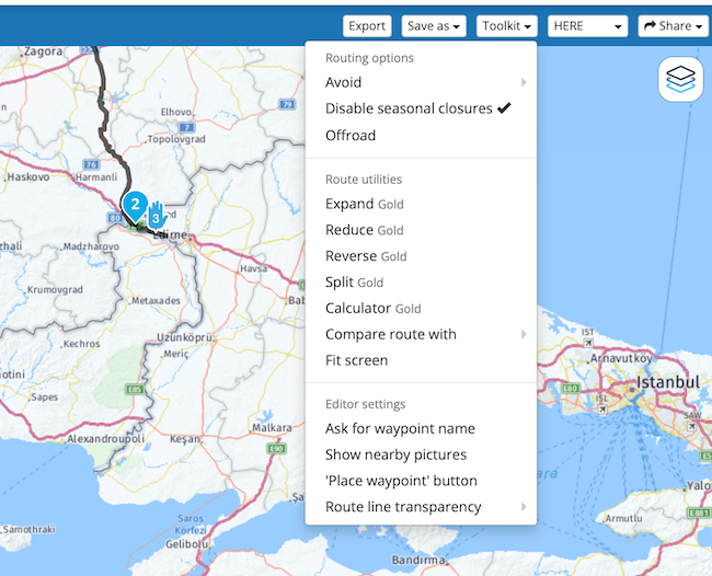
the above options are only available for Gold users.
-
@Andrzej-0
I have used the indicated waypoints and only run into problems with SHELL 22130 KEMAL EDIRNE TURKYE.
But I solved that by using the Here map and enabling the "Disable seasonal closures" option.
By the way: If you want to use the TomTom map, you will have to take into account that the options "Hilness & curves" and "Curves" work for routes with a maximum length of 900 kilometers.the above options are only available for Gold users.
@Jack-van-Tilburg said in ERROR planing route too long:
By the way: If you want to use the TomTom map, you will have to take into account that the options "Hilness & curves" and "Curves" work for routes with a maximum length of 900 kilometers.
Thanks @Jack-van-Tilburg.
Every day is a school day, I wasn't aware there was a limit.
I use the Tom Tom Curvy/Windy Routes all the time and map them to the Here Map with Waypoints.
I guess I've never created a route that long before.You don’t stop riding when you get old, you get old when you stop riding.
-
@Jack-van-Tilburg said in ERROR planing route too long:
By the way: If you want to use the TomTom map, you will have to take into account that the options "Hilness & curves" and "Curves" work for routes with a maximum length of 900 kilometers.
Thanks @Jack-van-Tilburg.
Every day is a school day, I wasn't aware there was a limit.
I use the Tom Tom Curvy/Windy Routes all the time and map them to the Here Map with Waypoints.
I guess I've never created a route that long before.
-
@Andrzej-0
I have used the indicated waypoints and only run into problems with SHELL 22130 KEMAL EDIRNE TURKYE.
But I solved that by using the Here map and enabling the "Disable seasonal closures" option.
By the way: If you want to use the TomTom map, you will have to take into account that the options "Hilness & curves" and "Curves" work for routes with a maximum length of 900 kilometers.the above options are only available for Gold users.
@Jack-van-Tilburg said in ERROR planing route too long:
@Andrzej-0
I have used the indicated waypoints and only run into problems with SHELL 22130 KEMAL EDIRNE TURKYE.
But I solved that by using the Here map and enabling the "Disable seasonal closures" option.
By the way: If you want to use the TomTom map, you will have to take into account that the options "Hilness & curves" and "Curves" work for routes with a maximum length of 900 kilometers.the above options are only available for Gold users.
-
@Andrzej-0
I have used the indicated waypoints and only run into problems with SHELL 22130 KEMAL EDIRNE TURKYE.
But I solved that by using the Here map and enabling the "Disable seasonal closures" option.
By the way: If you want to use the TomTom map, you will have to take into account that the options "Hilness & curves" and "Curves" work for routes with a maximum length of 900 kilometers.the above options are only available for Gold users.

Hello! It looks like you're interested in this conversation, but you don't have an account yet.
Getting fed up of having to scroll through the same posts each visit? When you register for an account, you'll always come back to exactly where you were before, and choose to be notified of new replies (either via email, or push notification). You'll also be able to save bookmarks and upvote posts to show your appreciation to other community members.
With your input, this post could be even better 💗
Register Login-
 41077
41077
-
 05115
05115
-
115763
-
 0439
0439
-
06222
-
07407
-
 0337
0337
-
 8974
8974