The Different .gpx Export & Save As Options
-
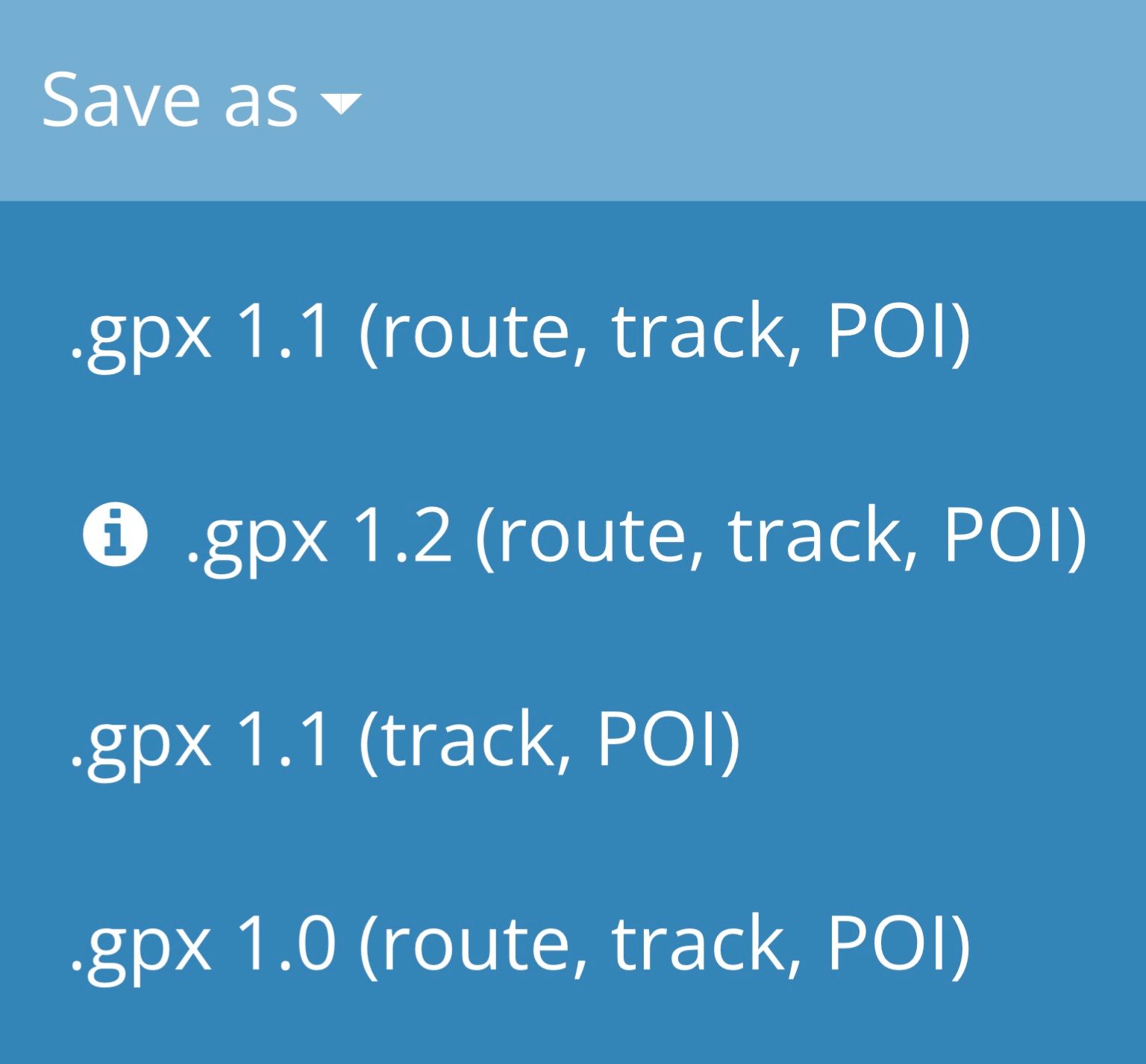
Under ‘Save As’ we are offered the following .gpx file options:
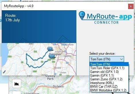
And using ‘Export’:
While the descriptions do tell us a little when using ‘Save As’, I do think they fail to tell users the most salient details. And the drop down in ‘Connector’ when using ‘Export’ offers no description.
While much has been regularly discussed in this forum about the various .gpx options, I have not seen any outline of their differences in one place and have remained uncertain as to what happens when, as a Garmin sat nav user, I use each variant. So, this evening I tried the three available via ‘Export’ in ‘Connector’ (a rare foray into using Routeplanner on PC for me) to see what I got for my trouble...
On creating three differently titled versions of the same route in order to ‘fool’ my Zūmo 390, I installed them onto it using .gpx 1.0, .gpx 1.1 and .gpx 1.2 respectively. The end results, once installed and loaded were:
.gpx 1.0 A track and an accurate route, but with all waypoints shown as via points (i.e. all shaping point locations present, but converted to via points).
.gpx 1.1 A track and an accurate route with all waypoints present and as created (i.e. shaping points and via points correctly displayed).
.gpx 1.2 A track and an accurate route but with only those via points included upon route creation in Routeplanner visible (given the accurate rendering of the route, I think it’s probably safe to say all shaping points are present and correct, just not shown?).
All three options apparently offer inclusion of any POI’s added to routes but I can’t verify this as I never use them*, but I have no reason to doubt that POI’s will be successfully transferred to the device.
No track and POI only option is available in ‘Connector’. I don’t use tracks as I find routes better suited to my needs. However, I did use ‘Save As’ to open a .gpx 1.1 (track, POI) version in BaseCamp… All good and as anticipated.
Don’t try opening a .gpx 1.2 in BaseCamp though - the two are definitely incompatible! (.gpx 1.2 is an MRA peculiarity, is not a current standard and, to my knowledge, is not found elsewhere).
Having completed this small exercise, I am now much clearer in my mind about which option works best for me in any given circumstances**, and I hope it is of some help to others(?). Maybe work through them using your particular Garmin (and presumably many, if not all, BMW Navigators?) to get the best insight. It didn’t take me very long to do it - about 15-20 minutes total from booting up the PC.
I do think that MRA could easily make a much better set of descriptors for the file types available in both ‘Save As’ and ‘Export’ though. It would make the process clearer and more user friendly.
(*I prefer instead to use self researched and checked locations and venues represented as named waypoints - likewise via points, though I do drop in an occasional one for fuel stops/breaks/rendezvous point for group rides)
(**almost always that will be .gpx 1.1 for me, but others may find greater use for the other types depending on sat nav model and waypoint preferences)
-
Under ‘Save As’ we are offered the following .gpx file options:
And using ‘Export’:
While the descriptions do tell us a little when using ‘Save As’, I do think they fail to tell users the most salient details. And the drop down in ‘Connector’ when using ‘Export’ offers no description.
While much has been regularly discussed in this forum about the various .gpx options, I have not seen any outline of their differences in one place and have remained uncertain as to what happens when, as a Garmin sat nav user, I use each variant. So, this evening I tried the three available via ‘Export’ in ‘Connector’ (a rare foray into using Routeplanner on PC for me) to see what I got for my trouble...
On creating three differently titled versions of the same route in order to ‘fool’ my Zūmo 390, I installed them onto it using .gpx 1.0, .gpx 1.1 and .gpx 1.2 respectively. The end results, once installed and loaded were:
.gpx 1.0 A track and an accurate route, but with all waypoints shown as via points (i.e. all shaping point locations present, but converted to via points).
.gpx 1.1 A track and an accurate route with all waypoints present and as created (i.e. shaping points and via points correctly displayed).
.gpx 1.2 A track and an accurate route but with only those via points included upon route creation in Routeplanner visible (given the accurate rendering of the route, I think it’s probably safe to say all shaping points are present and correct, just not shown?).
All three options apparently offer inclusion of any POI’s added to routes but I can’t verify this as I never use them*, but I have no reason to doubt that POI’s will be successfully transferred to the device.
No track and POI only option is available in ‘Connector’. I don’t use tracks as I find routes better suited to my needs. However, I did use ‘Save As’ to open a .gpx 1.1 (track, POI) version in BaseCamp… All good and as anticipated.
Don’t try opening a .gpx 1.2 in BaseCamp though - the two are definitely incompatible! (.gpx 1.2 is an MRA peculiarity, is not a current standard and, to my knowledge, is not found elsewhere).
Having completed this small exercise, I am now much clearer in my mind about which option works best for me in any given circumstances**, and I hope it is of some help to others(?). Maybe work through them using your particular Garmin (and presumably many, if not all, BMW Navigators?) to get the best insight. It didn’t take me very long to do it - about 15-20 minutes total from booting up the PC.
I do think that MRA could easily make a much better set of descriptors for the file types available in both ‘Save As’ and ‘Export’ though. It would make the process clearer and more user friendly.
(*I prefer instead to use self researched and checked locations and venues represented as named waypoints - likewise via points, though I do drop in an occasional one for fuel stops/breaks/rendezvous point for group rides)
(**almost always that will be .gpx 1.1 for me, but others may find greater use for the other types depending on sat nav model and waypoint preferences)
@pad-0
well done, I have always used GPX1.1 great to have it confirmed as a good choice. -
I ended up doing the same sort of trial and error exercise - you are quite right MRA could make this much clearer. I imagine a lot of users spend time creating a really good route for themselves, only to be disappointed when they come to actually ride it. Sorting this out would enhance usability...
Hello! It looks like you're interested in this conversation, but you don't have an account yet.
Getting fed up of having to scroll through the same posts each visit? When you register for an account, you'll always come back to exactly where you were before, and choose to be notified of new replies (either via email, or push notification). You'll also be able to save bookmarks and upvote posts to show your appreciation to other community members.
With your input, this post could be even better 💗
Register Login-
1936.3k
-
0470
-
014221
-
0258
-
17438.7k
-
255613.0k
-
0949
-
04159