Planned Route vs Nav Interpretation


-
@Con-Hennekens the same issue happened again today, not the same route, but exactly the same issue. Tried to use Nav App to plot a simple Point A to B route, a short and simple route. When I clicked the yellow Nav button, the route changed to something completely different.
I have detailed the erratic behaviour into a word document - how do I get that to you so you can see? I also have the *.gpx file saved from MRA Gold, which I can also send to you. I had to 'plan' the route in MRA, then access it when done and navigate from it. The route then was executed as originally desired, as shown in the first set of pics in the documented file I made.
EDIT: I have made the MRA planned route public, so you should be able to grab it from my profile.
This is extremely frustrating!
@GT-JWR, What's the distance of the route? in A2B routes there can be differences between the planning an driving stage because of traffic info.I f you want to drive a specific road, you will need to add shaping points to the route.
This forum has the copy and paste function of images enabled. Everything you can copy into a word document, you can also copy directly into your forum message.
-
@Con-Hennekens the same issue happened again today, not the same route, but exactly the same issue. Tried to use Nav App to plot a simple Point A to B route, a short and simple route. When I clicked the yellow Nav button, the route changed to something completely different.
I have detailed the erratic behaviour into a word document - how do I get that to you so you can see? I also have the *.gpx file saved from MRA Gold, which I can also send to you. I had to 'plan' the route in MRA, then access it when done and navigate from it. The route then was executed as originally desired, as shown in the first set of pics in the documented file I made.
EDIT: I have made the MRA planned route public, so you should be able to grab it from my profile.
This is extremely frustrating!
Used your route and add some points. Also placed point 1 on the road
Garmin Zumo XT3/XT2/XT/BMW Connected Ride Navigator/Tourstart/ MyRouteapp (The App)/...
Een dag niet gelachen is een dag niet geleefd / Een route is net zo goed als deze uitgezet is. -
Used your route and add some points. Also placed point 1 on the road
@Hans-van-de-Ven-MRA-Master that is exactly what I did to 'make' it take the route as intended.
The point, however, was to simply enter point B into the Nav app itself, and not have to plan additional waypoints - it was an extremely short route, around 6mi. And when I did that, the route came up exactly as intended, and as you have shown, above. However, when clicking on Navigate in the app, it competley changed the route, taking highway and roads not intended, nor 'allowed' based on the settings.
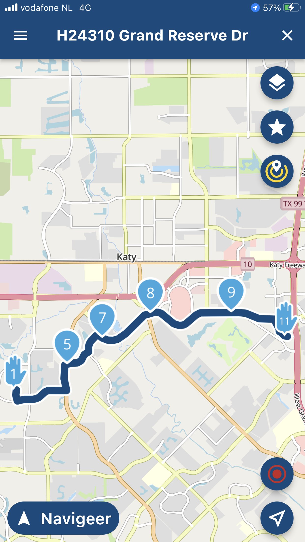
Pic 1: point A to B route only, done on Nav App only. Route drew EXACTLY as I wanted, no need for change.

Pic 2: continuation of pic 1, to show entire route (unable to capture entire route in 1 pic),

Pic 3: continuation of pic 2, to show end point (B). Point A to B, desired route, complete – per Nav App.

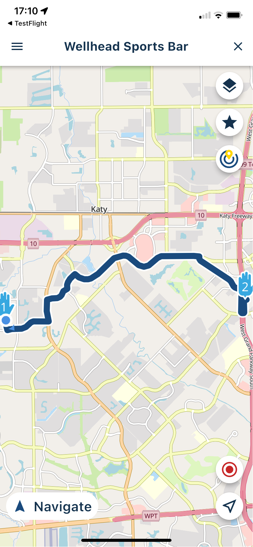
Pic 4: how the route ‘drew’ after pressing the yellow Nav button in pic 3.
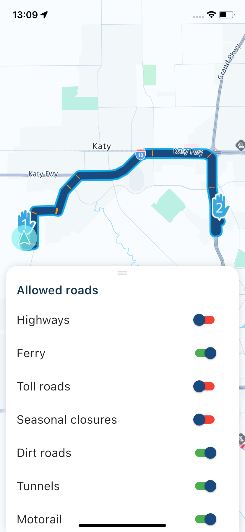
NOTE: Point A to B was used to ‘Avoid Hwy”. There were no Tolls to worry about, so this was the only absolute I desired. You can see the route settings in the very last pic

Pic 5: continuation of pic 4, to show how erratic the route became, simply by pressing the yellow Navigate button.

Pic 6: continuation of pic 5 to show route erratically chosen by pressing yellow Navigate button.
NOTE: the Katy FWY portion is Interstate 10, arguably, the largest interstate in Houston, and perhaps the longest in the USA all together – there is a REASON the setting to avoid Highways was selected.


NOTE: even the alternative, grayed out route does not mirror the original Point A to B as desired.
If you wish to try entering the route into your App to see what it does, use the following addresses:
Point A: 2620 FM 1463, Katy, TX 77494 (this is close enough to the actual Point A, which is my home – no need for real home address.Point B: 23410 Grand Reserve Dr, Katy, TX
And here is how I ended up drawing it in MRA to get it to take the route desired - which, ironically, is very similar to what you also drew up.
The odd thing is that the Nav app drew it up exactly as wanted, and eventually planned - however, when time to start the route from the Nav app, it was completely different (highways) and erratic.

bolded text
-
@Hans-van-de-Ven-MRA-Master that is exactly what I did to 'make' it take the route as intended.
The point, however, was to simply enter point B into the Nav app itself, and not have to plan additional waypoints - it was an extremely short route, around 6mi. And when I did that, the route came up exactly as intended, and as you have shown, above. However, when clicking on Navigate in the app, it competley changed the route, taking highway and roads not intended, nor 'allowed' based on the settings.
Pic 1: point A to B route only, done on Nav App only. Route drew EXACTLY as I wanted, no need for change.
Pic 2: continuation of pic 1, to show entire route (unable to capture entire route in 1 pic),
Pic 3: continuation of pic 2, to show end point (B). Point A to B, desired route, complete – per Nav App.
Pic 4: how the route ‘drew’ after pressing the yellow Nav button in pic 3.
NOTE: Point A to B was used to ‘Avoid Hwy”. There were no Tolls to worry about, so this was the only absolute I desired. You can see the route settings in the very last pic
Pic 5: continuation of pic 4, to show how erratic the route became, simply by pressing the yellow Navigate button.
Pic 6: continuation of pic 5 to show route erratically chosen by pressing yellow Navigate button.
NOTE: the Katy FWY portion is Interstate 10, arguably, the largest interstate in Houston, and perhaps the longest in the USA all together – there is a REASON the setting to avoid Highways was selected.
NOTE: even the alternative, grayed out route does not mirror the original Point A to B as desired.
If you wish to try entering the route into your App to see what it does, use the following addresses:
Point A: 2620 FM 1463, Katy, TX 77494 (this is close enough to the actual Point A, which is my home – no need for real home address.Point B: 23410 Grand Reserve Dr, Katy, TX
And here is how I ended up drawing it in MRA to get it to take the route desired - which, ironically, is very similar to what you also drew up.
The odd thing is that the Nav app drew it up exactly as wanted, and eventually planned - however, when time to start the route from the Nav app, it was completely different (highways) and erratic.
bolded text
See your first pictures, the 4 icons, the choice you select there, is how the route is calculated from A to B.
The first option is fast, the second curvy etc etc.I think the settings are only for planned routes
Garmin Zumo XT3/XT2/XT/BMW Connected Ride Navigator/Tourstart/ MyRouteapp (The App)/...
Een dag niet gelachen is een dag niet geleefd / Een route is net zo goed als deze uitgezet is. -
See your first pictures, the 4 icons, the choice you select there, is how the route is calculated from A to B.
The first option is fast, the second curvy etc etc.I think the settings are only for planned routes
@Hans-van-de-Ven-MRA-Master that is my understanding, yes. And if I did select one of the other options, the route did indeed change - which is expected.
The 'fast' route still happened to draw as I had wanted, it just did not translate to actually starting navigation - and that is where I am at a loss - if it drew up the route, and you like it, then when starting the navigation, it should be the route. At this point, I would have expected the NAV App to have behaved like Google Maps or Apple Maps....but it didn't.
Sadly, I guess the easy answer is - do not depend on the Nav App alone to make the route.
Thanks for the response.
-
Just to add a quick comment. The fastest route selected in the first screens doesn't take any traffic or actual Navigation info into account.
When you start the route and you enter the Navigation module, these factors are taken into account and HERE will suggest a fastest route. As the app knows you just want the fastest route - the difference between possible routes is taken for granted in all honestly.
If however you would select a curvy route, we know you want to drive a scenic route. Meaning that HERE will navigate exactly the generated route in the first screen. This is then the more technical term called: track navigation
@Corjan-Meijerink ok - that definately explains why it has happened on more than one occasion.
I also see this as a 'bug' - will future updates also include traffice scenarios, etc, when using fastest on the Nav App? Seems like it should be there, or have the Nav App generate 2 or 3 options so the one wanted can be selected?
-
@Corjan-Meijerink ok - that definately explains why it has happened on more than one occasion.
I also see this as a 'bug' - will future updates also include traffice scenarios, etc, when using fastest on the Nav App? Seems like it should be there, or have the Nav App generate 2 or 3 options so the one wanted can be selected?
@GT-JWR yeah we might do that!
")
-
@Corjan-Meijerink ok - that definately explains why it has happened on more than one occasion.
I also see this as a 'bug' - will future updates also include traffice scenarios, etc, when using fastest on the Nav App? Seems like it should be there, or have the Nav App generate 2 or 3 options so the one wanted can be selected?
@GT-JWR said in Planned Route vs Nav Interpretation:
I also see this as a 'bug'
In my previous career our developers would say: "a bug is never a bug until the dev says so"
After what Corjan explains I can only conclude it is "by design", and there is logic to it. If you want the fastest route, you get the fastest route, even if circumstances are changing. If you want a curvy (or scenic) route, you get a route that does not deviate by circumstances.I am just an enthusiastic MRA user, and hope you will be one too!
Most motorcycle problems are caused by the nut that connects the handlebar to the saddle.
Check out RideSleepRepeat.eu, a biker community for sharing stays across Europe
-
@GT-JWR said in Planned Route vs Nav Interpretation:
I also see this as a 'bug'
In my previous career our developers would say: "a bug is never a bug until the dev says so"
After what Corjan explains I can only conclude it is "by design", and there is logic to it. If you want the fastest route, you get the fastest route, even if circumstances are changing. If you want a curvy (or scenic) route, you get a route that does not deviate by circumstances.@Con-Hennekens understood. However, irregardless of fastest, curviest, etc, the route that is drawn up at the start, if selected, should be the route to use.
If the app has the abillity to provide multiple 'fast', 'curvieset', etc, even better.
In the instance I refer to, the route drawn up was not the same as when the actual navigate button was hit - that is the point.
-
@Con-Hennekens understood. However, irregardless of fastest, curviest, etc, the route that is drawn up at the start, if selected, should be the route to use.
If the app has the abillity to provide multiple 'fast', 'curvieset', etc, even better.
In the instance I refer to, the route drawn up was not the same as when the actual navigate button was hit - that is the point.
@GT-JWR, I understand that, but that has little impact if you just want the fastest route to a single destination.
Hello! It looks like you're interested in this conversation, but you don't have an account yet.
Getting fed up of having to scroll through the same posts each visit? When you register for an account, you'll always come back to exactly where you were before, and choose to be notified of new replies (either via email, or push notification). You'll also be able to save bookmarks and upvote posts to show your appreciation to other community members.
With your input, this post could be even better 💗
Register Login-
023474
-
729342
-
0477
-
0637.2k
-
1987.9k
-
0349
-
06165
-
03116