How to handle the tet routes
-
Hi,
When I import the TET track it first is visible as a track in MRA. If I want to work on it it makes it to a route but it changes the route drimaticaly. Probably MRA does not like the off road routes. How can I make it to a route and still use it? So a route including off road?
Arjan
-
Hi,
When I import the TET track it first is visible as a track in MRA. If I want to work on it it makes it to a route but it changes the route drimaticaly. Probably MRA does not like the off road routes. How can I make it to a route and still use it? So a route including off road?
Arjan
That would depend on what device you are using to navigate.
The majority of hardware navigation devices will only plot routes on “proper” roads.
There are some Garmin Devices that can do it like the Montana range and also the Garmin Zumo XT.
These devices can display the off-road track.
I have never used any of the Garmin Montana devices but I have done it on the Garmin Zumo XT.
Basically you get to see the track on the map and you just follow it visually, it does not give you any turn notifications or voice prompts.There are a quite a few Phone Apps that can plot/import off road routes.
Here’s 2 that popped up Googling “GPX Off Road Navigation Apps”.
ONX (iOS & Android)
Gaia GPS (iOS & Android)The only “Off-Road” App I personally use, other than the TET App, is OSMaps which is UK specific only.
I don’t use MRA for Off Road stuff I go direct to the Garmin XT from GPX files saved on my PC.
In theory you could do it in MRA but the issue is that the Open Street Maps gives no indication of off road tracks that Motorcycles can and cant travel on and not all tracks appear on it in full. (This may be UK Specific)Below is an example of my Garmin Zumo XT with every “Green Lane” individually plotted in the OS Maps app for Salisbury Plain and placed into a Garmin Collection to make them all visible on the Garmin XT Map.
As mentioned above, you get no turn by turn notifications or voice prompts you simply visually follow the red lines.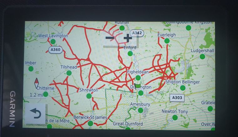
-
Hi,
When I import the TET track it first is visible as a track in MRA. If I want to work on it it makes it to a route but it changes the route drimaticaly. Probably MRA does not like the off road routes. How can I make it to a route and still use it? So a route including off road?
Arjan
@Arjan-de-Vries, No MRA does not like Offroad routes indeed. It is possible to use a piece of offroad within a regular route, but if you need to navigate ar create offroad tracks, MRA is not the tool for that. Sorry.
I am just an enthusiastic MRA user, and hope you will be one too!
Most motorcycle problems are caused by the nut that connects the handlebar to the saddle.
Check out RideSleepRepeat.eu, a biker community for sharing stays across Europe
-
@Arjan-de-Vries, No MRA does not like Offroad routes indeed. It is possible to use a piece of offroad within a regular route, but if you need to navigate ar create offroad tracks, MRA is not the tool for that. Sorry.
@Con-Hennekens Well, better use basecamp then! I am an old basecamp user so I can manage the software.
-
@Arjan-de-Vries use the off-road option in the toolbox, you wil get straight lines then
-
Oh yes, I may have been a bit too harsh in what I said earlier. I was under the impression that waypoints had to be skipped one by one, but as @Hans-van-de-Ven-MRA-Master pointed out, you can put the whole route into offline-mode through the toolkit. Then, if you are Gold member you can change to the TOPO map and with that you have a much better terrain view. I think it is pretty similar to Basecamp afterall.
Hello! It looks like you're interested in this conversation, but you don't have an account yet.
Getting fed up of having to scroll through the same posts each visit? When you register for an account, you'll always come back to exactly where you were before, and choose to be notified of new replies (either via email, or push notification). You'll also be able to save bookmarks and upvote posts to show your appreciation to other community members.
With your input, this post could be even better 💗
Register Login-
7673.2k
-
019514
-
09119
-
05157
-
314886
-
115758
-
0116